San Diego
Walking Tours
Home Page

Shelter Island
a walking tour by Carol Mendel

Shelter Island, named for the protection it gives to yachts and small boats against southerly and southeasterly winds, is the home of yacht clubs, sportfishing boats, public moorings, launching ramps, motels, restaurants, yacht-brokers, ship chandlers, public parks, and superb views of the city and San Diego Bay. Connected to the mainland by a causeway (and therefore not really an island at all), it is immensely popular with both visitors and residents, and a delightful place to explore on foot.
fountain by James Hubbell
Fountain at tip of Shelter Island


Once, for a period lasting at least a million years, it was nothing more than a mud bank, a submerged shoal, lying off Point Loma. In 1934, however, the City of San Diego began dredging the bay and dumped some of the surplus material on the shoal. Similar additions occurred in the late '30's and in the '40's. In 1950 the City added a 2000-foot causeway, along with enough dredgings to raise the former mud bank comfortably above sea level, began landscaping the island with palm trees, and allowed commercial development to begin.

This self-guided walking tour is especially nice on a Saturday or Sunday, for then San Diego Bay is speckled with small sailboats, the launching ramps are busily catering to motorboats, and the park along the bay is bustling with picnickers. But on a weekday you will find a lot of activity in the marine yards, so take your pick. Either way, you're in for a pleasant adventure.

Distance: Two miles. Time: An hour and a half. Note: This walk does not bring you back to your starting point, so plan either to walk or to get a ride back.

MAP of the walking tour

Terms of Use


Japanese Friendship Bell
Begin your walking tour at the Bell of Friendship, at the tip of Shelter Island. This bell, weighing two and a half tons, hangs in an open wooden building with a Buddhist motif. It was presented to San Diego in 1958 by her "sister city," Yokohama, Japan.

view of La Playa from Shelter Island
View of La Playa from Shelter Island
Walk across the road, past the Harbor Police building, to the shoreline. Looking across the water you can see the Riviera-like homes of the La Playa district of Point Loma. The blue ships usually seen just south of La Playa are research vessels of the Scripps Institution of Oceanography. A little farther south is a Navy research station.

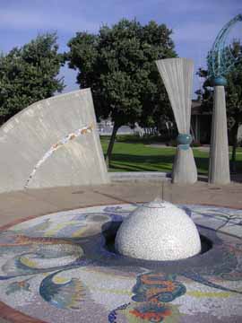
Follow the shoreline, and walk along the bay side of Shelter Island. As you start out, you pass a mosaic tile fountain designed by local artist James Hubbell. (See photo at the top of this page.)

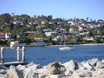
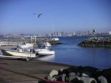
You can see out past the entrance to San Diego Bay to the Pacific Ocean. Across the entrance to the bay is North Island Naval Air Station. Look for its fleet of planes on the ground.

Tunaman's Memorial
Tunaman's Memorial
Before long you come to the Tunaman's Memorial, a handsome bronze sculpture of three fishermen working to bring in a catch. Beyond the memorial is a children's playground, and then the popular Shelter Island Fishing Pier. Take a walk out on the pier to see what's being caught. As you continue your walk, a strip of sand soon appears and becomes a fine bathing beach. The beach and the grass are particularly popular on weekends.

Shelter Island Launching Ramp
At the end of the beach, walk out on the spit that encloses the Shelter Island Launching Ramp, and watch the busy skippers sliding their small motorboats and sailboats into or out of the water.

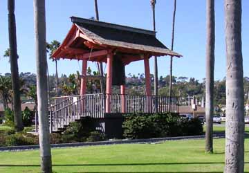
Continuing on, you pass the Shelter Island Gazebo, also designed by local artist James Hubbell.

America's Cup Harbor
Rounding the tip of Shelter Island, you now walk southwest. The boats of Shelter Cove Marina remind you that San Diego is one of the yachting meccas of the United States. Just before you reach the traffic circle, a small, sturdy pier provides a good spot from which to survey the boats. This area is called America's Cup Harbor, in honor of the America's Cup yacht races held in the Pacific Ocean off San Diego in 1988, 1992, and 1995.

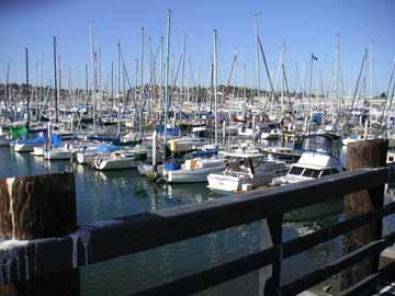
Leaving the pier, walk a few yards farther, and then go around to the right on Shelter Island Drive. Shelter Island Drive is lined with small shops that sell marine products and services to the boating community. Stop at the edge of a marine repair yard to see the boats in dry dock for repairs.

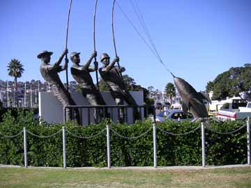
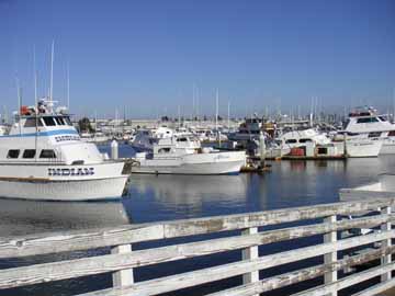
On the left side of the road you will find the weighing station of The Marlin Club. The marlin season runs from late July to early November. During these months the scales are put to heavy use when the marlin boats come back to port with their catches in the late afternoon. A good-sized marlin weighs 150 pounds and, including its sword, is six to seven feet long.

Le Rondelet condominiums
Turn left at Anchorage Lane. On your right, the round Le Rondelet condominiums sit on the site once occupied by a Starkist tuna factory. Turn right at Cañon Street, and right again at Shafter Street. Take a few steps to the left on Avenida de Portugal to see two buildings of the Portuguese community -- a tiny wood frame chapel and the large United Portuguese S.E.S. meeting hall.

SES hall sign
United Portuguese SES Hall
The hall is used regularly for Portuguese social functions, religious celebrations, and wedding parties. Painted above the doorway are United States and Portuguese flags. The letters S. E. S. stand for Sociedade do Espírito Santo, Society of the Holy Spirit.

Portuguese chapel
Portuguese chapel
The chapel is used only on special occasions, such as the Festa do Espírito Santo, Feast of the Holy Spirit. This celebration is held every year on Pentecost Sunday, seven weeks after Easter. The festa features a parade that begins at the chapel, proceeds to the nearby Catholic church for mass, then returns to the chapel for an afternoon of feasting, singing, and dancing. The food includes home-made wine and a special Portuguese sweet bread flavored with lemons and mint.

If you are taking this walk on a Saturday afternoon, you might want to stop in at the Portuguese Historical Center, across the street from the chapel.

Return to Shafter Street, and continue along it. Cross Shelter Island Drive and walk to the right. Just past the Intrepid Boat Works, turn left onto the concrete path that leads out to the water. Follow the path around to the left along the water's edge.

Point Loma sportfishing docks
Soon you will come to the docks and offices of several sportfishing companies. If you like sportfishing, you might stop to arrange a fishing trip.

Alternatively, you may be able to schedule a whale-watching trip. From December through March, day trips take whale viewers out to watch whales as they make their way past Point Loma.

In any case, end your walk by going out onto the docks to look at the fishing boats.

Return to top.

Copyright © by Carol Mendel


Enjoy this walking tour?

Check out the others in this series

Balboa Park

Cabrillo National Monument

Downtown San Diego

The Embarcadero

La Jolla

La Playa

Mission Bay Park

Mission Beach

Old Town

Shelter Island

Sunset Cliffs

Enjoy full-color
illustrated maps?


Check out the ones below.

Some can be purchased as laminated maps, some as folded maps, some as wooden trays, and some as all three.

San Diego

Los Angeles

Palm Springs

Santa Barbara

San Francisco Bay Area

Las Vegas

Salt Lake City

Oregon

Washington DC


Return to top.


Home Privacy Contact About Sitemap